


Applications

Technical Specifications
| Signal tracking | Channels: 965 GPS: L1C/A, L2C, L2P, L5 BDS: B1I, B2I, B3I, B1C, B2a, B2b GLONASS: L1, L2, L3 Galileo: E1, E5a, E5b, E6, AltBOC QZSS: L1C/A, L1C, L2C, L5 NavIC: L5 SBAS: WAAS, EGNOS, MSAS, GAGAN, SDCM, BDSBAS |
| Cold Start | < 50s |
| Warm Start | < 30s |
| Hot Start | < 15s |
| Signal reacquisition | <1.5 s |
| RTK Initialization time | <10 s |
| Initialization Reliability | >99.99% |
| Static / fast static | H: 2.5 mm + 0.5 ppm; V: 5 mm + 0.5 ppm |
| Long observations static | H: 3 mm + 0.1 ppm; V: 3.5 mm + 0.4 ppm |
| RTK | H: 8 mm + 1 ppm; V: 15 mm + 1 ppm |
| DGPS | <0.4 m RMS |
| SBAS | 1 m 3D RMS |
| Standalone | 1.5 m 3D RMS |
| Tilt | Up to 60° with 2.5 cm accuracy |
| Dimensions | Ø158 × 75 mm |
| Weight | 0.95 kg with two batteries |
| Power consumption | 1.92 W¹ |
| Input voltage | 7-28 VDC |
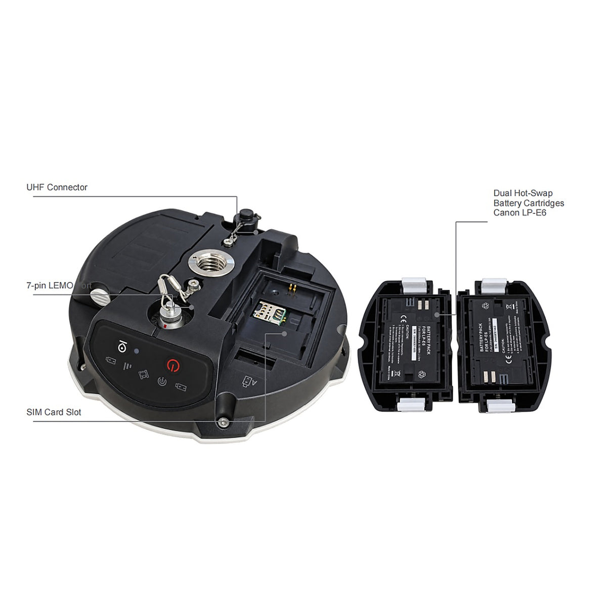
| Batteries | 2 × 2000 mAh; up to 14 h typically |
| Memory | 8 GB; optional 16 GB or 32 GB |
| Working temperature | -40 °C to +65 °C |
| Storage temperature | -40 °C to +85 °C |
| Humidity | 100% non-condensing |
| Water & dust protection | IP67; temporary immersion to 1 m |
| Drop resistance | Designed to survive a 2 m drop onto concrete |
| 1 × 7-pin LEMO | Combined serial and USB |
| UHF Tx/Rx | 410-470 MHz |
| Spacing | 12.5 kHz |
| Transmit power | 0.5 W / 1 W / 2 W adjustable |
| Air baud rate | 9600 / 19200 / 11000 |
| Range | 3-15 km |
| Protocols | Transparent / TT450S / South / Mac / SNLonglink |
| Wi-Fi | 802.11 a/b/g/n, 2.4 GHz |
| 4G LTE-FDD | B1/B2/B3/B4/B5/B7/B8/B12/B13/B18/B19/B20/B25/B26/B28 |
| LTE-TDD | B38/B39/B40/B41 |
| WCDMA | B1/B2/B4/B5/B6/B8/B19 |
| Output rates | 1 / 2 / 5 / 10 / 20 Hz |
| Bluetooth 4.0 | Windows and Android compatible |
| 5 LEDs | Power, satellites, GPRS and differential data |
| Correction I/O | RTCM 2.X, 3.X, CMR, CMR+ |
| NMEA-0183 | GSV, RMC, HDT, VHD, GGA, GSA, ZDA, VTG, GST; PTNL, PJK; PTNL, AVR; PTNL, GGK |
| ComNav Binary | Up to 20 Hz |
Note:
1. ¹ Power increases during UHF transmission.
2. ² Range depends on environment; 15 km under ideal conditions.
3. UHF and 4G are standard and may be removed on request. Specifications subject to change.
1. ¹ Power increases during UHF transmission.
2. ² Range depends on environment; 15 km under ideal conditions.
3. UHF and 4G are standard and may be removed on request. Specifications subject to change.
- Choosing a selection results in a full page refresh.
- Opens in a new window.